Jul-30-2021
Old Downtown Part I: North.
St. Augustine is considered the oldest, permanent European settlement in the USA. It’s not a huge city area-wise, but it is filled to the brim with amazingly beautiful historic sites and attractions! This tour begins in the north at the Castillo de San Marcos fort and makes its way through the heart of the city-center, ending at the Grace United Methodist Church, where the next tour picks up if you’re interested in doing them back to back.
Guide Type: Self-guided Walking Tour
# of Attractions: 11
Tour Duration: 90 Minutes
Travel Distance: 1.6 Km or 1 Miles
Sights Featured in This Guide:
- Castillo de San Marcos
- Old Spanish Trail Zero Milestone
- Fuentos de los Canos de San Francisco
- Old City Gate
- Potter’s Wax Museum
- Oldest Wooden Schoolhouse
- Colonial Quarter
- St. George Street
- Cathedral Basilica of St. Augustine
- Plaza de la Constitucion
- Grace United Methodist Church
https://goo.gl/maps/jWKSrFWtULbi4bWF9
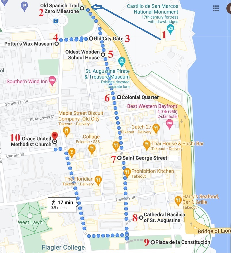
1) Castillo de San Marcos
The oldest masonry fort in the continental United States, the Castillo de San Marcos is a large Spanish stone fortress built to protect and defend Spain’s claims in the New World. It’s a National Monument and, at over 315 years old, it’s the oldest structure in St. Augustine. It’s also one of the main attractions visitors to St. Augustine come to see
Passes to the Castillo may be purchased at the ticket booth on site (open from 8:45 a.m. to 4:45 p.m.) or online. Adults (16 years and older) $15.00 per person.
The metered parking lot at the Castillo allows visitors to park there and visit the city.
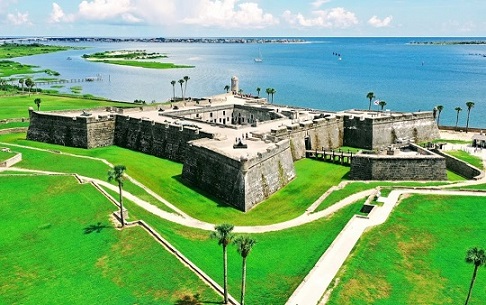
2) Old Spanish Trail Zero Milestone
In the 1920s, an ambitious transcontinental road project linked St. Augustine and San Diego. Called the Old Spanish Trail, Route 90 provided Jazz Age motorists easy access to the gracious towns strung along the interior of North Florida and beyond.
The Old Spanish Trail (OST) transcontinental highway was one of the most prominent and persistent American auto trails. It connects the old Spanish colonial towns of St. Augustine, Florida on the Atlantic coast and San Diego, California on the Pacific. The OST highway is not to be confused with the 19th century cattle trail of the same name that wound from Santa Fe to Los Angeles.
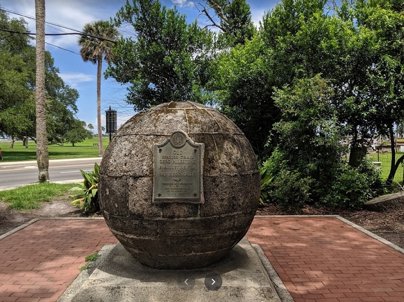
Other landmarks at the Visitor Information Center include a fountain on the side of the building that was given as a gift to St. Augustine from Aviles, Spain. The fountain is a replica of a fountain in Aviles known as the Fuentos de los Canos de San Francisco and features 6 faces with water pouring from their mouths.
3) Old City Gate
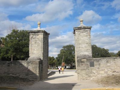
In 1808 the residents of St. Augustine erected the pillars of the City Gate using coquina blocks. The Cubo Line was also reconstructed at the same time. The City Gate pillars still stand today, along with reconstructed portions of the Cubo Line marking the beginning of St. George Street leading visitors though the heart of the city.
4) Potter’s Wax Museum
Potter’s Wax Museum is said to be the first wax museum in the United States. From famous politicians and entertainers to horror characters and historical personalities, Potter’s Wax Musuem seems to have it all. It also has a theater and a wax studio.
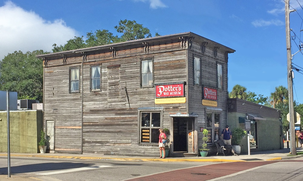
This unique attraction was founded over 50 years ago when George L. Potter began the business in 1949. He employed some of the finest talents in the world to make his wax figures, using meticulous research on every aspect of the person being depicted, right down to each freckle on the skin and hair on the head. The costumes of the original figures were created by B.J. Simmons and Nathan’s, Ltd., the finest costumers of their day, and certified for historical accuracy by the British Historical Society.
5) Oldest Wooden Schoolhouse
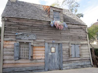
The Oldest Wooden School House dates back to the early 18th century and is located on St. George Street by the City Gate. Visitors to the Oldest Wooden School House can tour the property and become acquainted with the daily life of colonial school children.
Visitors can view copies of old textbooks and school supplies from the eighteenth century, and tour the kitchen and gardens, where a fruitful pecan tree has been growing for an estimated 250 years.
The house has a large chain wrapped around the exterior. The chain was added in 1937 in order to hold the house in place in case of hurricane-force winds and weather.
6) Colonial Quarter
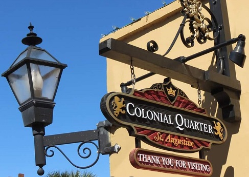
The Colonial Quarter is where visitors can experience hundreds of years of Colonial Spanish and British living history in St. Augustine. This two-acre revamped attraction takes vacationers and locals back in time through three centuries of the formation and creation of the nation’s oldest city.
7) St. George Street
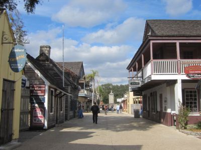
Walking around downtown St. Augustine, you’ll find our ‘sky-scrapers’ are church domes and historical spires. Our city noise is the sound of horse hoofs and trolley bells. Fast food means getting home-cooked baked goods from a local counter. We don’t have potted-plants, but a city built around plants, and St. George Street is where the hustle, bustle, and beauty of downtown converge. You’ll see the town square with its towering oaks. Further, into the shopping district towards Hypolita, you’ll see palm trees shading businesses, and strip malls filled with a multitude of shops selling clothing, wines, cigars, housewares, books, and souvenirs. The energy of St. George Street, the sights, all make for an invigorating
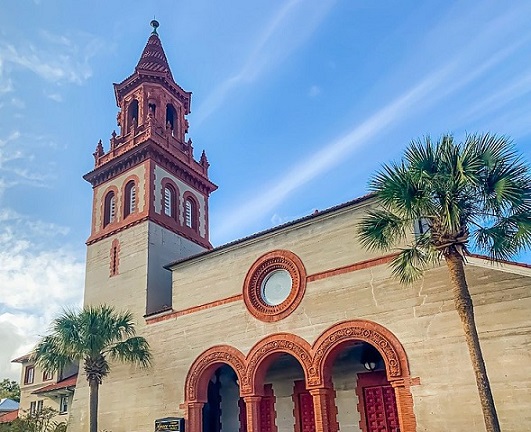
8) Cathedral Basilica of St. Augustine
America’s first parish and the oldest Catholic Church in the city. Free Entry
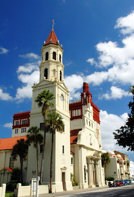
This is the oldest Catholic Church in the city, and the seat of the Bishop of the Diocese of St. Augustine. The architecture of the Cathedral is inspired by the city’s Spanish roots.
The cathedral walls are adorned with exquisite murals that depict scenes from the history of the Catholic Church in the development of the New World. There are also stained glass windows showing scenes from the life of Saint Augustine of Hippo, for whom the city was named.
Guided tours are offered throughout the day, and visitors are welcome to light candles for loved ones at any time. Mass is celebrated at 7:00 a.m. Monday through Saturday.
9) Plaza de la Constitucion
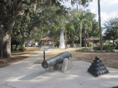
The plaza has been a central part of St. Augustine since 1573 when it was first laid out by the Spanish Royal Ordinances. The Ordinances required that the plaza be laid in a rectangular shape according to the compass points, with the length equal to 1 1/2 times the width in order to promote harmony. The plaza earned its proper name for the obelisk that was erected to celebrate the Spanish Constitution of 1812. Other monuments included in the park include a tribute to American Revolution prisoners, the Confederacy, and soldiers killed in WWII, the Korean War, and the Vietnam War. There is also a monument to commemorate the civil rights movement in St. Augustine known as the Foot Soldiers Monument, and a statue of Father Felix Varela in the East courtyard of the Cathedral.
10) Grace United Methodist Church
In 1886 Henry Flagler began construction on the Ponce de Leon Hotel. He had grand plans for this hotel and its courtyard, but there was one small problem; the Olivet Church sat where he wanted to build. To solve his dilemma Mr. Flagler bargained with the trustees. He offered to not only give them the land on the corner of Carrera Street and Cordova Street, but to build them a new, beautiful church as well, in exchange for the land on which the Olivet Church was located. They took him up on his offer and he had the same architects that would build his hotel build the trustees’ new church, which is why the Grace United Methodist Church has the same Mediterranean Eclectic style as the Flagler buildings.
Old Downtown Part II: South
This tour begins at the Grace United Methodist Church, where the Old Downtown North tour ended, and explores the southern half of The Ancient City.
Guide Type: Self-guided Walking Tour
# of Attractions: 6
Tour Duration: 75 Minutes
Travel Distance: 1.1 Km or 0.7 Miles
Sights Featured in This Guide:
- Memorial Presbyterian Church
- Villa Zorayda
- Flagler College/ Ponce de Leon Hotel
- City Hall and Lightner Museum/Alcazar Hotel
- Casa Monica Hotel
- Medici Lion Statue on Bridge of Lions
1) Memorial Presbyterian Church
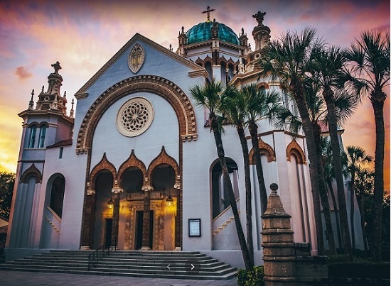
Flagler’s Memorial Presbyterian Church was dedicated on March 16, 1890. The old Presbyterian Church on St. George Street was vacated as the congregation moved to the new sanctuary with room for 480 worshipers. Flagler built the church for his daughter Jennie Louise Flagler, who died in 1889. He chose the same architects who built the Ponce de Leon for him, Carrere & Hastings. Its design is based on the Basilica of St. Mark in Venice, Italy.
Visitors are welcome to take a self-guided tour of the beautiful church between the hours of 11:00 a.m. and 3:45 p.m. on Monday through Saturday.
2) Villa Zorayda
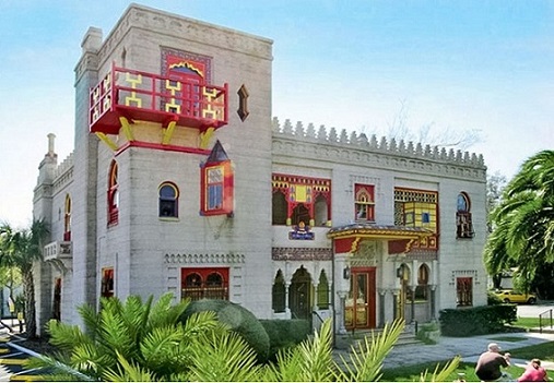
Designed by Franklin Smith in 1883 to be his private home, this structure is the first modern building in St. Augustine to have been created by poured concrete, which makes it among the first modern buildings in all of the USA to have been made this way. Listed on the National Register of Historic Places, this grand Gilded Age home is built 1/10th the scale of a portion of the Moorish castle, the Alhambra Palace in Granada, Spain. When Flagler later began his surge of building projects throughout St. Augustine he and his architects greatly imitated this building style, which reflects the city’s Spanish roots.
In addition to the magnificent architecture of the building is the collection of antiques and fine art, featuring paintings, seventeenth-century furniture, beautiful hanging brass lamps, oriental rugs, and an Egyptian rug over 2,400 years old that was originally taken from one of the pyramids in Egypt.
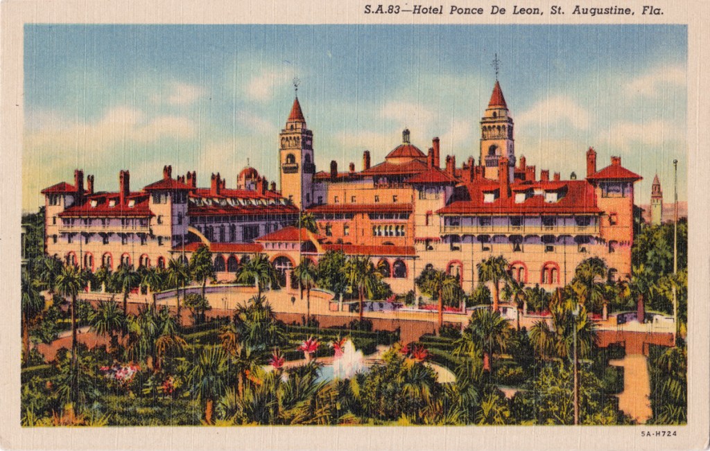
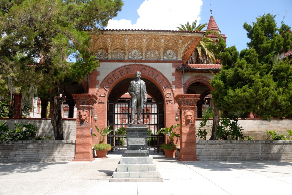
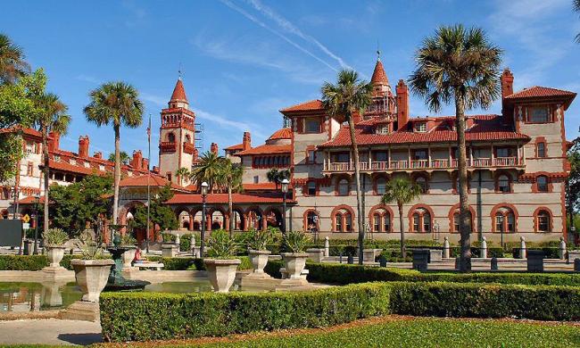
3) Flagler College
Flagler College, housed in what was once one of Henry Flagler’s most opulent Gilded-Age hotels in St. Augustine, is a private four-year college. The college opened in 1968 and now offers 32 majors, 44 minors, and two pre-professional programs. With an enrollment of 2,500 students, the college draws students from all over the world to study liberal and fine arts in this magnificent setting in the nation’s oldest city.
The Ponce de Leon hotel was built in 1887 and is listed as a National Historic landmark.
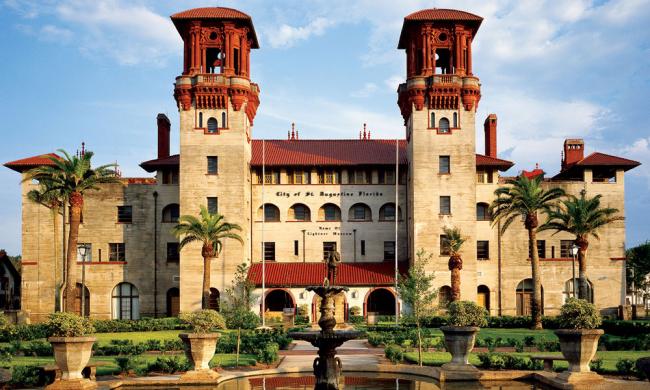
4) City Hall and Lightner Museum
The Lightner Museum is housed in the former Alcazar Hotel, which was built in 1888. Henry M. Flagler commissioned architects Carrere and Hastings to construct this architectural masterpiece. The Alcazar closed during the Depression, and in 1948 the building was purchased by Otto Lightner, who was editor and publisher of Hobbies Magazine in Chicago. Lightner converted the hotel into a museum to contain his vast collection of decorative and fine arts. He bequeathed the building to a board of directors who then opened it to the public several years later. The building is on the National Register of Historic Places and today is home to both the Lightner Museum and City government offices.
5) Casa Monica Hotel
Franklin Smith built the Casa Monica around the time Flagler was building his hotels and is part of the reason that Flagler began investing in Florida. The Casa Monica is one of the oldest hotels in the country and is even listed in the “Historic Hotels of America” National Trust. It’s named after St. Monica, the mother of the city’s namesake, St. Augustine of Hippo. Shortly after the hotel opened, Franklin Smith ran into financial difficulties, and unfortunately had to sell the hotel and everything inside to his friend Henry Flagler. Flagler changed the name of the hotel to the Cordova Hotel.
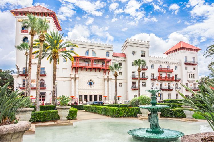
During the 1960s, the hotel was turned into the offices for the St. Johns County Courthouse. The iconic window above the Casa Monica lettering was decorated with a stained glass window portraying the scales of justice. It served as a courthouse for years, until it was purchased by Richard Kessler for $1.2 million. Kessler had previously been involved with the Days Inn chain and was looking to bring the hotel back to its former glory. Construction and renovations took less than two years, and the hotel was reopened in 1999.
This hotel is quite literally fit for royalty, with even the King and Queen of Spain as past guests. Former President Bill Clinton stayed here, as has former First Lady and Secretary of State, Hillary Clinton. Archbishop Desmond Tutu, a Nobel Peace Prize winner, rested his head at the Casa Monica. When the Gentlemen of the Road Tour came to St. Augustine, Edward Sharpe and the Magnetic Zeroes shacked up at Casa Monica along with John Fogerty and members of the Billboard-topping band, Fun.
6) Medici Lion Statue on Bridge of Lions
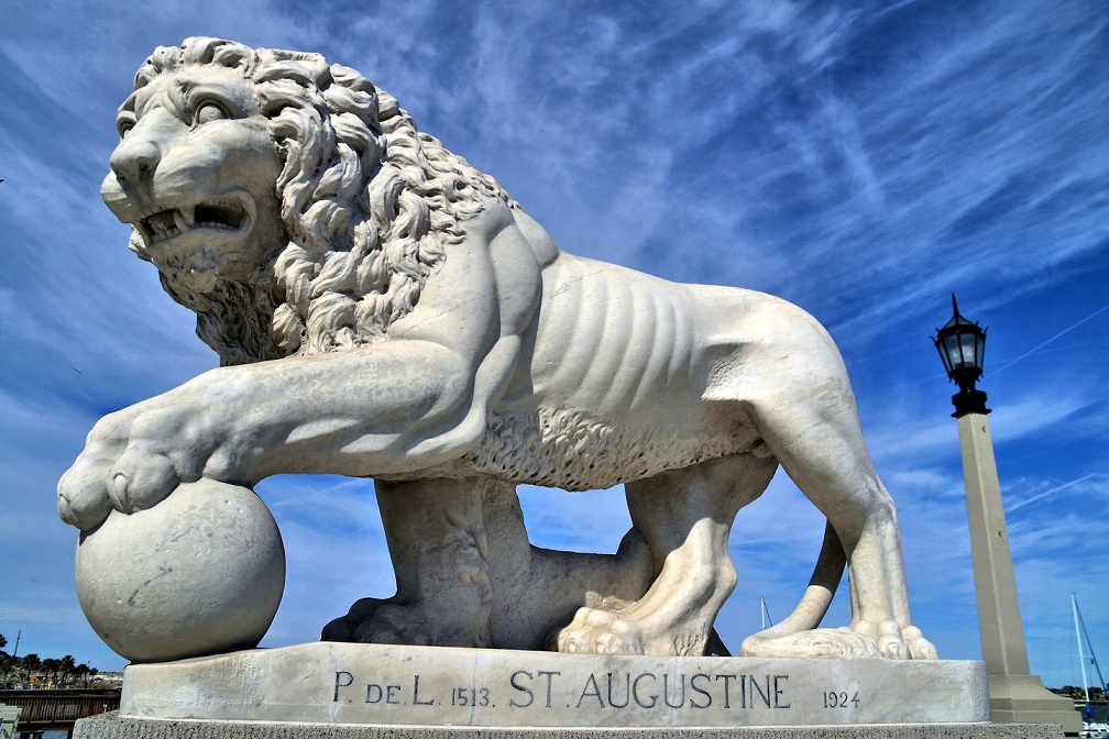
This Carrara marble Medici lion is one of two guarding the entrance to the Bridge of Lions in St. Augustine, Florida. These carvings by F. Romanelli were a gift from local philanthropist Dr. Andrew Anderson. The bridge has been called “The Most Beautiful Bridge in Dixie.” It is even more beautiful after an $80 million restoration was finished. The male lion with his paw on an orb was patterned after the originals commissioned in 1576 for the Italian garden of Ferdinando I dé Medici, the Grand Duke of Tuscany. The pair from the 16th century is now in the Loggia dei Lanzi in Florence, Italy.
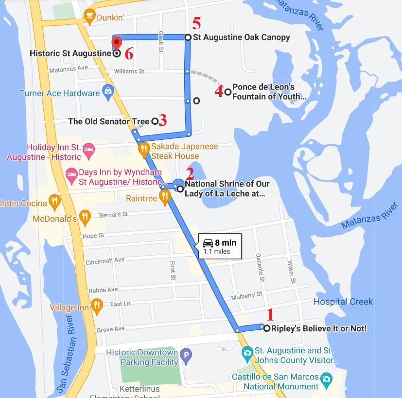
St Augustine Self-guided Driving Tour.
Sights Featured in This Guide:
- Ripley’s Believe It or Not!
- National Shrine of Our Lady of La Leche at Mission Nombre de Dios
- The Great Cross
- The Old Senator Tree
- Fountain of Youth
- St Augustine Oak Canopy
- Historic St Augustine
- Castle Otttis
- Bridge of Lions
- St. Augustine Lighthouse
- Alligator Farm Zoological Park
- Avendia Menendez
- Gonzalez-Alvarez House
- Upham Winter Cottage
https://goo.gl/maps/1nWFXENgoPvs2Gsw8
1) Ripley’s Believe It or Not !
The museum is the original Ripley’s Believe it or Not, opening in 1950 just a few months after Robert Ripley’s death. Here, people can explore and interact, witness incredible illusions and see for themselves what Ripley collected from his travels around the world—many too outlandish to believe.
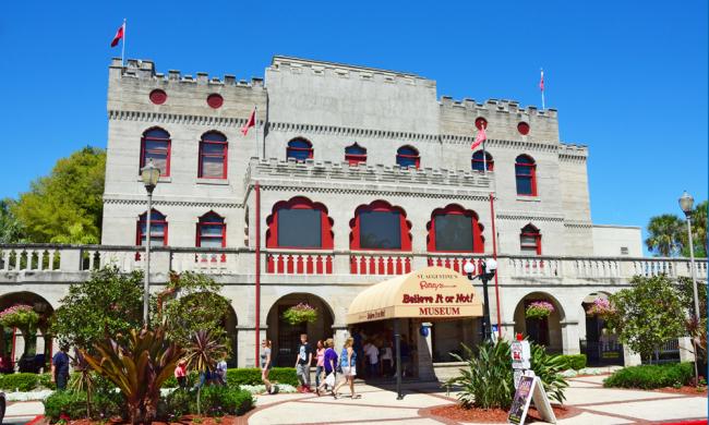
Ripley’s Believe It or Not! in St. Augustine is housed in the former Castle Warden Hotel, so even the building is curious! Many employees of Ripley’s say they hear or see the ghosts of the two women that died in a fire at the Castle Warden in April of 1944. The hotel’s own eccentric past made it the ideal location to showcase Ripley’s fascinating collection after his passing in 1949.
2) The Shrine of Our Lady of La Leche at Mission Nombre de Dios
The Shrine of Our Lady of La Leche at Mission Nombre de Dios traces its origins to the founding of the city of St. Augustine in 1565. On September 8, 1565, Pedro Menéndez de Avilés landed and proclaimed this site for Spain and the Church. Menéndez named this site Nombre de Dios, meaning Name of God. He put Father Lopez in charge of the mission, making him the first parish priest in St. Augustine.

It was on these grounds that Father Lopez celebrated the first parish Mass and began the work at America’s first Mission. At Mission Nombre de Dios, guests will find numerous artifacts, both sacred and secular, from the very beginning of the Spanish settlement in St. Augustine.
A walking tour of Mission Nombre de Dios includes a number of interesting stops: the Prince of Peace Church, the Father Lopez Statue built by Dr. Ivan Mestrovic, the Great Cross, the Mission Plaque, Our Lady of Guadalupe Shrine, the Our Lady of Perpetual Help, Chapel of Our Lady of La Leche, and Our Lady of La Leche Shrine, and the Rustic Altar. Visitors can also tour archaeological excavation sites or go into the Shrine Shop.
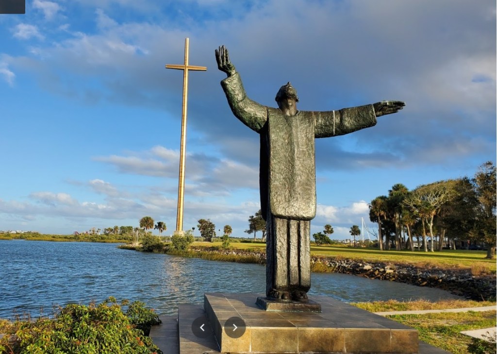
The Shrine of Our Lady de la Leche at Mission Nombre de Dios is the oldest Marian Shrine in the U.S., and it was recently elevated to a National Shrine by the U.S. Conference of Catholic Bishops.
The Shrine of Our Lady of La Leche at Mission Nombre de Dios is located at the Great Cross just north of downtown St. Augustine. Parking is free. Entrance to the grounds are restricted to their daily hours, 9:00 a.m. to 5:00 p.m. Monday through Saturday, and noon to 4 p.m. on Sunday. Only service animals are allowed on the grounds.
3) Old Senator Live Oak
Visit the oldest resident of St. Augustine, the “Old Senator” Live Oak tree,
“Old Senator” is over 600 years old and grows in the courtyard of Villa 1565 on San Marco, just a short distance from historic downtown St. Augustine.
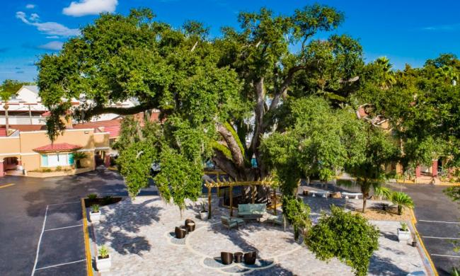
According to the website “Monumental Trees,” in 2016 “Old Senator’s” girth measured over 21 feet and “his” height was over 56 feet. Long considered to be St. Augustine’s oldest resident, “Old Senator” could certainly tell many stories about St. Augustine’s history and people.
4) Fountain of Youth
The Fountain of Youth Archaeological Park is a 15-acre, waterfront historical attraction, where visitors can learn about the first Spanish settlers who came here in the 1600s and the native Timucuans who were here to greet them. With a working archaeological dig on site, as well as several re-created Spanish and Timucuan buildings and dwellings, the park is bursting with history.
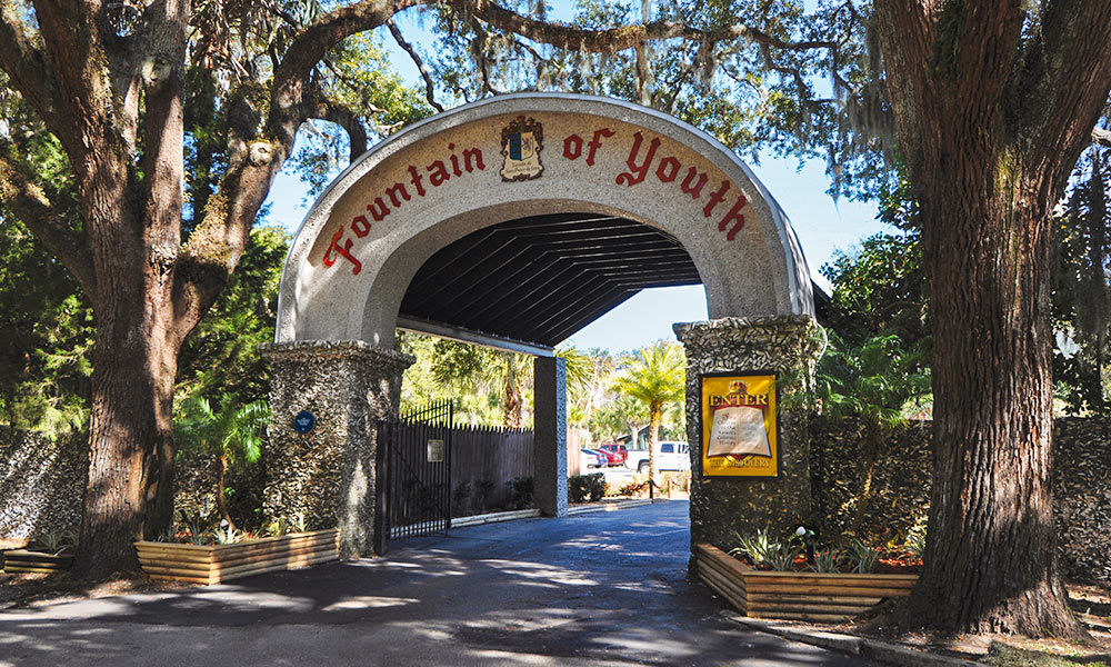
The Fountain of Youth Archeological Park is the site of the first Spanish settlement in the new world. Founded by Spanish explorer Pedro Menéndez de Avilés in 1565, this is the oldest continuously occupied European settlement in North America. Long before the Spanish came to La Florida, the Timucuan Indian village was established at this site for nearly 3,000 years. In 1513, Juan Ponce De Leon claimed Florida for the Spanish crown, though no colonies were successful here until Menéndez arrived in 1565.
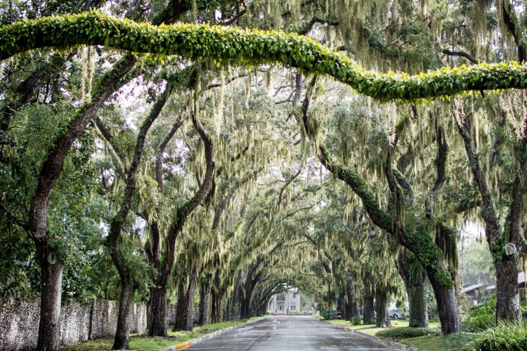
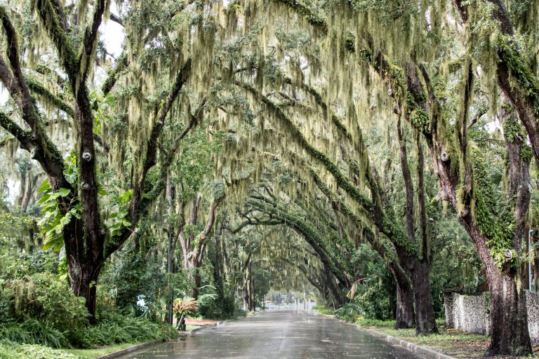
5) St Augustine Oak Canopy
Magnolia Avenue in St. Augustine is one of the most beautiful streets in the United States because of the arching live oak canopy and Spanish moss.
6) Historic St Augustine
This historic jail served the city of St. Augustine from 1891-1953. Visitors can take tours of the jail during the day or night, experiencing history as inmates in period dress guide them through the women’s cells, men’s cells, and the maximum security cells where only the most dangerous criminals were kept.
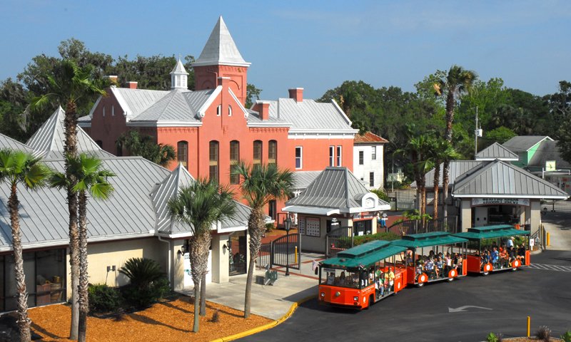
The Old Jail’s unique history is full of fascinating stories about individual inmates that once occupied the cells and the sheriffs (and their families!) who lived just across the hall from them.
The Old Jail is located at Old Town, along with the Old Town Trolley main station, The Oldest Store Museum, The St. Augustine History Museum, and a gift shop.
7) Castle Otttis
CASTLE OTTTIS (YES, THREE ‘T’S) was built by Ottis Sadler and Rusty Ickes between 1984 and 1988. Based on Irish castles from 1,000 years ago, it was designed to be a landscape sculpture, open to the elements and rising up more than 50 feet.
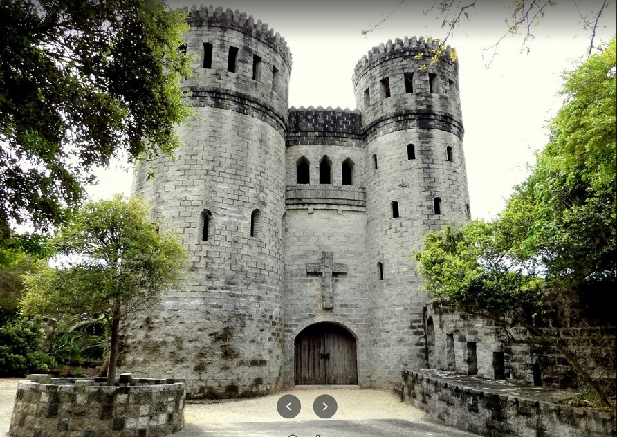
When Sadler and Ickes began work on the castle, it was never intended to be a residence or a business. Their ultimate aim was to create a work of art, one that would invoke the spirit of an old Irish abbey or Christian church.
The final result: a majestic stone castle built as an expression of artistic and spiritual devotion. And, of, course, an impressive new landmark along the St Augustine shoreline, one officially recognized by the American Institute of Architects in 1992.
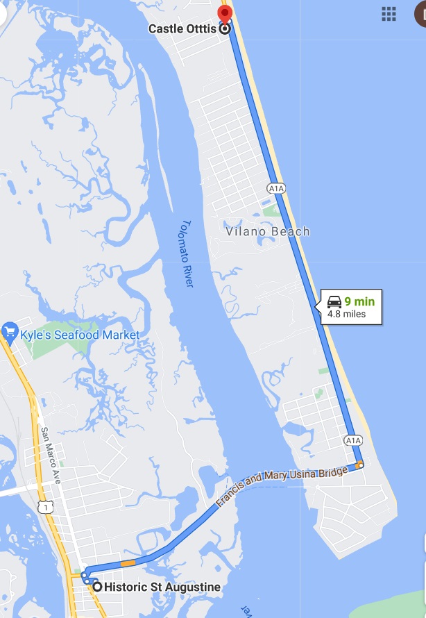
https://goo.gl/maps/k6SAmzgiZMzWwaUz7
+++
————————————
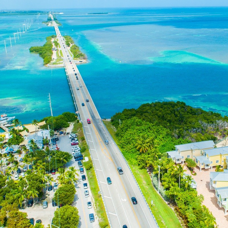
8) Bridge of Lions
The Bridge of Lions was built in the mid-1920s as a way for automobiles to travel from St. Augustine on the mainland to Anastasia Island, where significant development was just getting underway.
Though the original development was considered a failure, it did provide the impetus behind the creation of St. Augustine’s beautiful Bridge of Lions, which was completed in 1927 and has been an icon of historic St. Augustine ever since.
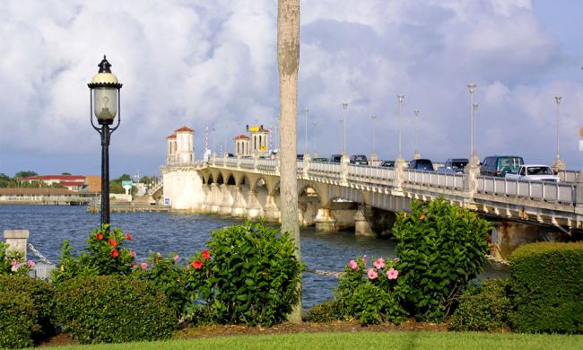
The bridge is a double-leaf bascule bridge, also known simply as a drawbridge, which allows commercial and recreational boats to pass through a center channel when the moveable span is in the up position. In 2010, it was renovated by the city of St. Augustine and still serves as a major thoroughfare from downtown St. Augustine to Anastasia Island.
The Bridge of Lions is listed on the National Register of Historic Places and is on every visitors list of must-see while in St. Augustine.
9) St Augustine Lighthouse
The St. Augustine Lighthouse is one of the city’s most treasured attractions. It stands as a testament to the ancient city’s perseverance and captivating history. The lighthouse dates back to 1874, but it doesn’t show! It is still a glorious attraction, with stunning gardens surrounding the space and an intriguing maritime museum for you to explore.
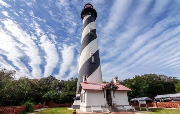
Free parking is available at the Museum. Summer hours are 9 a.m. – 7 p.m. The Museum is closed on Thanksgiving and Christmas Day. The Museum is located on Anastasia Island on the road around the corner from the fire station, across from the Alligator Farm.
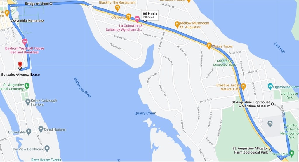
10) St. Augustine Alligator Farm Zoological Park
The Alligator Farm Zoological Park features a variety of animal species, including hundreds of native alligators. The allure of wild reptiles and their powerful presence entice thousands of vacationers to visit the park in St. Augustine each year. Exhibits include lemurs, Komodo dragons, toucans, and a sloth exhibit. The park is the only place in the world to see all 24 species of crocodilians in one place.
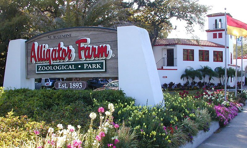
Opening their doors in 1893, the St. Augustine Alligator Farm Zoological Park is one of the oldest attractions in the area. George Reddington and Felix Fire began this attraction with their own collection of alligators in South Beach on Anastasia Island. After a series of storms and fires, the St. Augustine Alligator Farm was moved to its current location closer to historic downtown St. Augustine.
https://goo.gl/maps/rQPqfLxxJDX5t87k6
11) Avenida Menendez
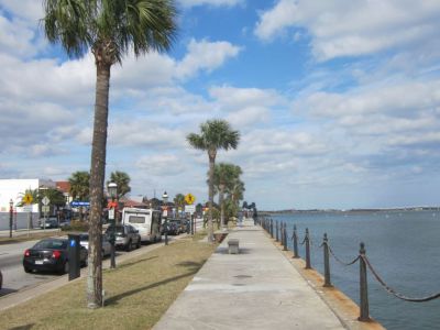
The Avendia Menendez is a scenic north-south road that was named after Pedro Menendez, the Spanish explorer and admiral who founded St. Augustine in 1565. The first sea wall against this street was constructed in the 1690s and was repaired several times until the 1830s when the United States of America finally replaced the original stone-shell coquina with concrete and granite. The section of the seawall north of the Plaza de la Constitucion is from the 1950s; at that time the street that is now Avenida Menendez was widened and that part of the seawall had to be rebuilt once again. Enjoy a stroll along the beautiful avenue.
12) Gonzalez-Alvarez House
The González-Alvarez House on St. Francis Street is commonly called “The Oldest House.” It is the oldest standing home from St. Augustine’s Spanish colonial period. A National Historic Landmark, the Stone Vernacular-style house dates to the early 1700s. It is part of the Oldest House Museum Complex, operated and maintained by the St. Augustine Historical Society.

The original structure was a simple home built of coquina, a sediment formed by ancient seashells. Additions and changes were made over the years. A small kitchen is separate from the main house. The complex includes a museum, garden and art gallery.
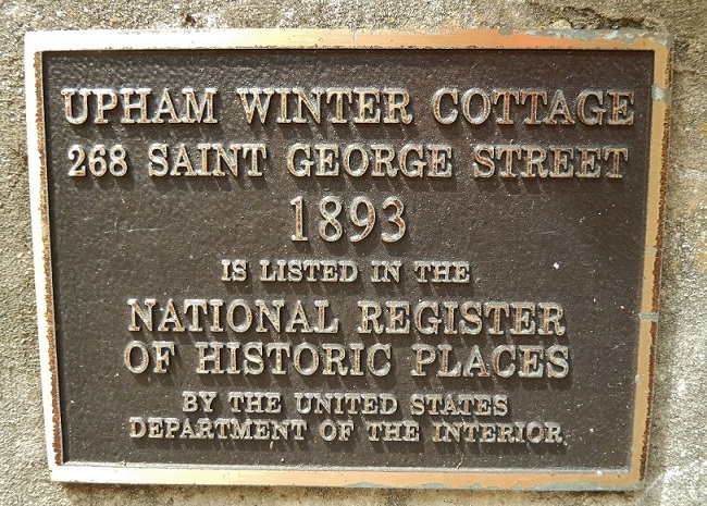
13) Upham Winter Cottage
The 1892 12-room Victorian cottage was originally built as Colonel John Upham’s winter home. It changed to apartment buildings some time in its past, but was restored to a private residence in the 1970s. It is not open to the public. It is said to be haunted by a pretty young woman named Claire who likes to play harpsichord music. Legend has it that her sea captain husband kept Claire imprisoned in the attic while he was away, and during one of his trips, she died there.
Cajun Crab Hut
2125 US Highway 1 South Suite A St, Augustine, FL 32086


—-
A1A Crab House Togo only
667 W King, St. Augustine, FL 32084