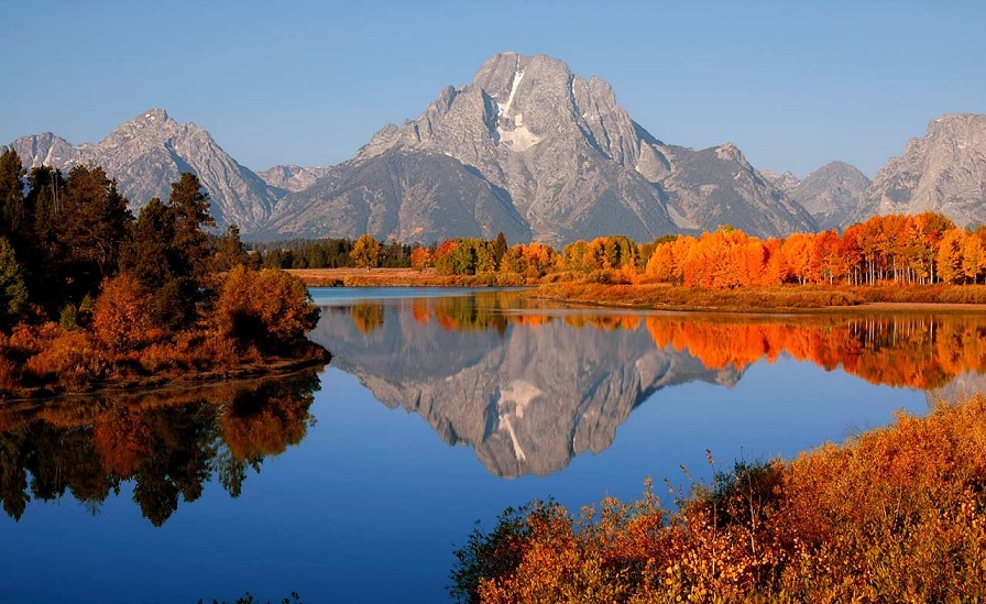
Canyonlands National Park may not be the most visited national parks in Utah, but it is the largest national park in Utah. It’s also one of the best places to see canyons, mesas, and buttes.
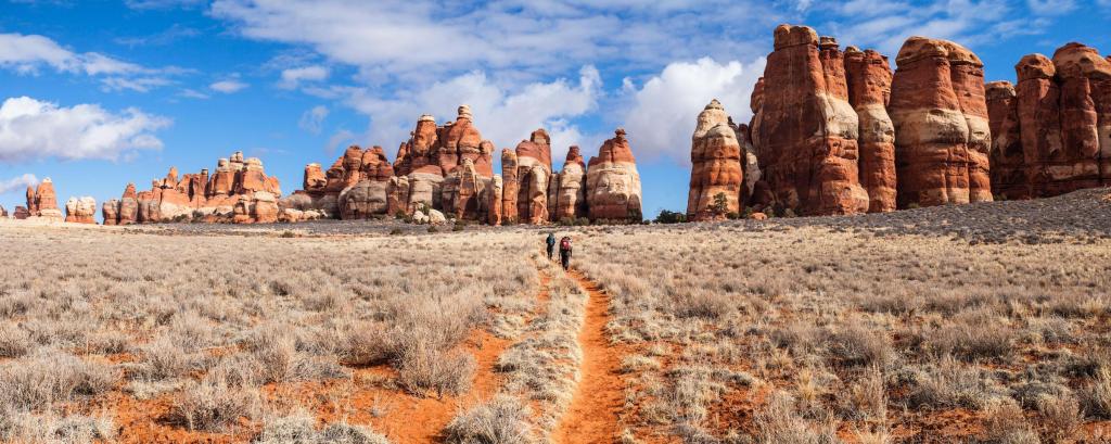
Canyonlands National Park preserves 337,598 acres of colorful canyons, mesas, buttes, fins, arches, and spires in the heart of southeast Utah’s high desert. Water and gravity have been the prime architects of this land, sculpting layers of rock into the rugged landscape we see today.
DIRECTIONS
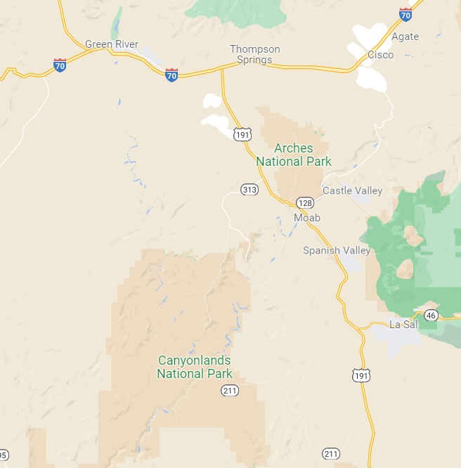
On US 191, drive 10 miles (16 km) north of Moab or 22 miles (35 km) south of Interstate 70 (Crescent Junction), then take UT 313 southwest for 22 miles (35 km). Driving time from Moab is roughly 40 minutes to the visitor center, or 60 minutes to Grand View Point.
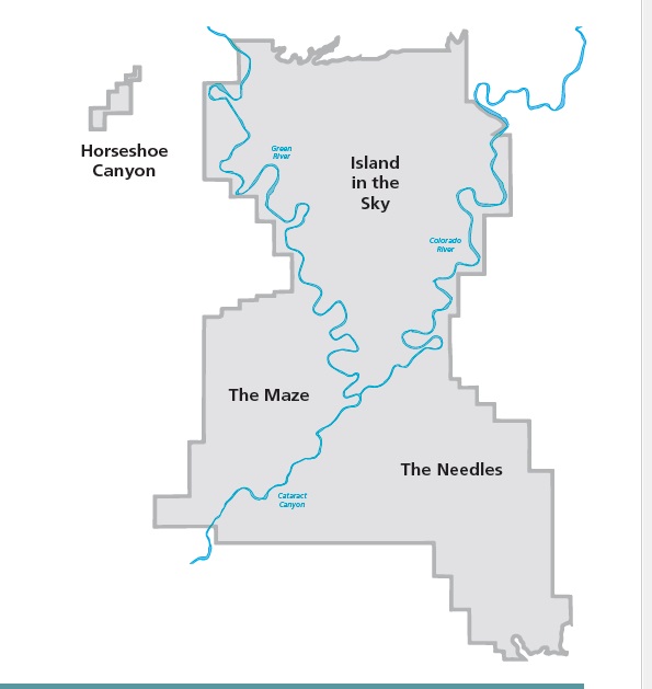
Four districts in Canyonlands National Park
Canyonlands preserves that natural beauty and human history throughout its four districts, which are divided by the Green and Colorado rivers. Island in the Sky is closest to Moab and is the most visited district. The Needles is a farther drive, and is great for a day trip or backcountry hiking and backpacking. The Maze is the most remote and rugged district, requiring a four-wheel-drive, high-clearance vehicle, and more time. The Maze’s Horseshoe Canyon unit contains intriguing rock markings from tribal cultures.
The Rivers separate the other three districts and offer world-class boating opportunities.
Island in the Sky
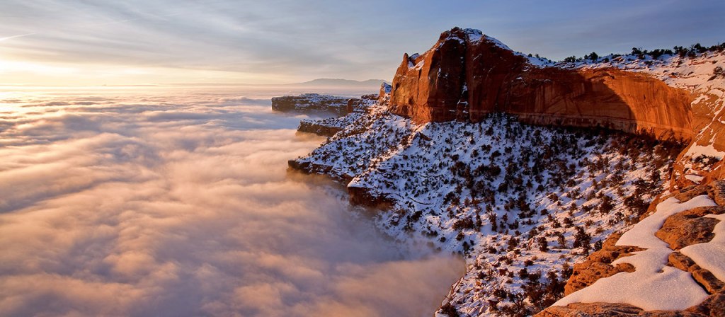
Canyonlands is split into three sections, also known as districts. These districts are a significant distance from one another and therefore not possible to cover all in one day. Island in the Sky, in the northern section of the park, is the district that we’ll cover in this post. It’s approximately a 40-minute drive, or 30 miles, from Moab. It’s called Island in the Sky since it sits on top of a 1,500-foot mesa, which gives visitors a panoramic view of the Canyon Country. Also, during certain times of the year, the mesa can be higher than the clouds, giving the appearance of an island in the sky.
Visiting the Island in the Sky, which is the most accessible section of Canyonlands.
Also, this isn’t meant to be an exhaustive list of things to see, but is instead just a sample in case you’re planning a day trip as well.
WHAT TO DO WITH YOUR DAY
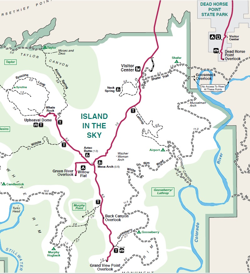
First, stop at the visitor center for current information on trails, roads, ranger programs, weather, or to watch the park movie.
In 2 hours you can: Drive to Grand View Point or Green River Overlook. Hike to Mesa Arch.
In 4 hours you can: Drive to Grand View Point, Green River Overlook, and Upheaval Dome. Hike the Grand View Point, Mesa Arch, and Upheaval Dome Overlook trails.
In 8 hours you can: Visit every overlook. Hike several mesa top trails or one of the more strenuous trails descending to the White Rim. Enjoy lunch on the trail, or picnic at White Rim Overlook or Upheaval Dome picnic areas.
Sunrise and Sunset: Visit Mesa Arch at dawn. Visit Green River Overlook or Grand View Point at dusk for incredible views of sunset over the canyons. Hike to the top of Aztec Butte or Whale Rock for a spectacular view of Island in the Sky and surrounding countryside.
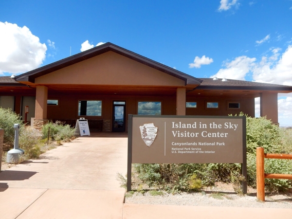
Visitor Center
Our first stop at Canyonlands National Park was the visitor center. As with every National Park we visit, we always stop at the visitor center to get the latest information about the park and useful insights from the park rangers. This is an easy stop, as it’s the first place you’ll see after driving through the park entrance.
Upheaval Dome
Next, we drove about 11 miles from the visitor center to Upheaval Dome. From the start of the trail, it’s about a 1-mile roundtrip hike to the first overlook. There are debates among geologists as to how this dome was formed. Some believe it’s a crater caused by the impact of a meteorite. Other scientists think that it’s the result of erosion from a natural salt dome. Either way, it’s an interesting sight to see and offers some beautiful views of the surrounding landscapes.
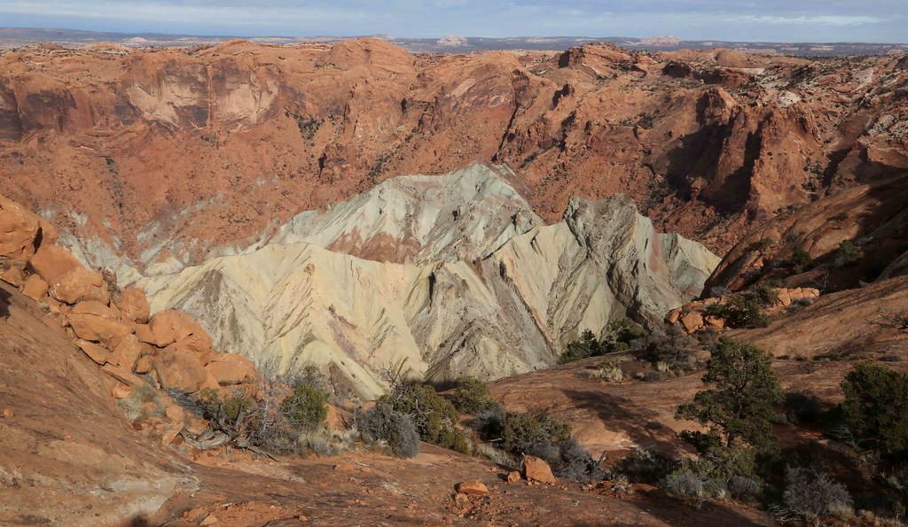
Upheaval Dome is a massive crater that offers interesting viewpoints
Green River Overlook
We then backtracked about 5 miles along the same route to Green River Overlook. This short stop was a great place to see the views over the Green River below. This was a popular photo spot and offered a different landscape to the miles of canyons that we had seen so far in the park.
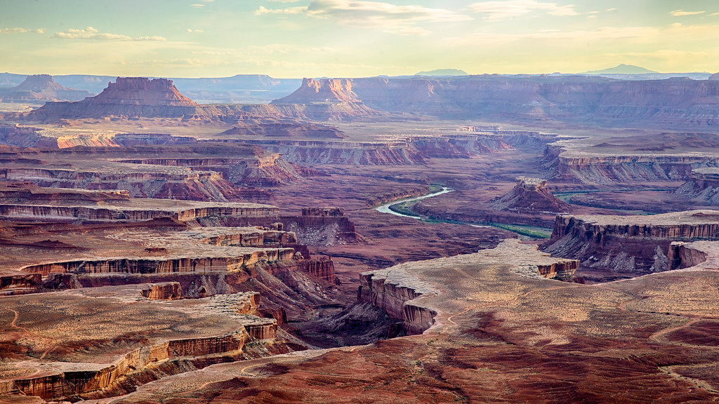
Green River Overlook offers some of the most incredible views of the Canyon Country.
Grand View Point Overlook
We then drove another 6 miles south to Grand View Point Overlook. This area has several hiking trails. The scenic views from this area are spectacular and worth checking out.
Grand View Point offers a spectacular view of the Canyonlands area. From the viewpoint at 6,080 feet elevation, you can see distant mountains, canyons, basins, and the White Rim Road.
Grand View Point is the southernmost point along the Island in the Sky scenic drive.
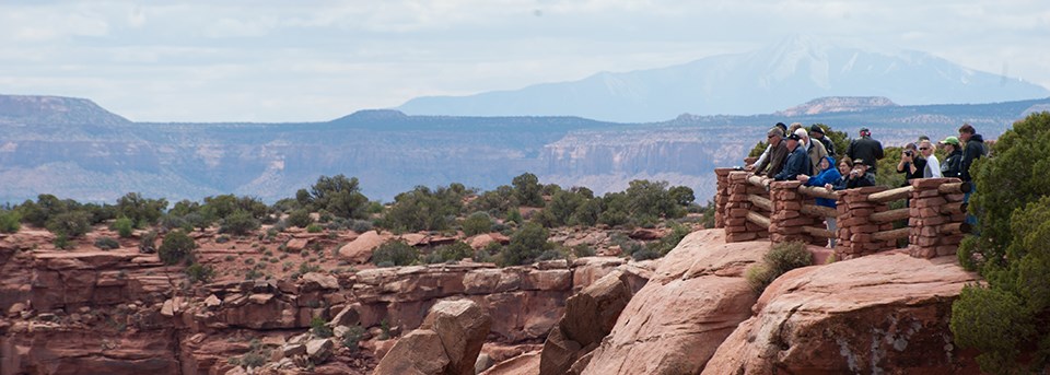
From the viewpoint, you can see many parts of the park as well as distant mountains.
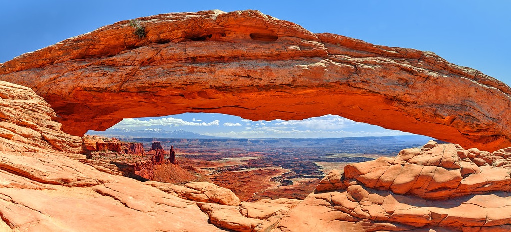
Mesa Arch
We then backtracked toward the center of the park for our last stop, which was Mesa Arch. It’s an easy 0.7-mile round trip hike to an interesting pothole arch, and it is one of the most popular sites in the park. If you’ve been to Arches National Park, you might not find this as spectacular as some of the natural arches in that area, but it’s still worth the short hike.
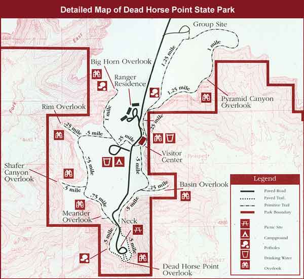
Additional stop: Dead Horse State Park
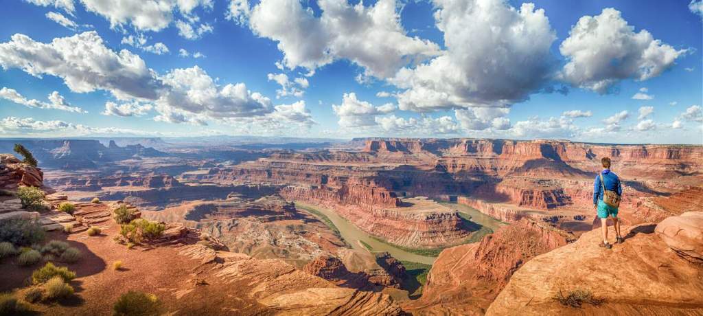
On our way back from the park, we stopped at Dead Horse Point State Park, which is a short distance from the park exit. Entrance to the state park isn’t covered by the national parks pass, so you should expect to pay $20 per vehicle if you’re planning a visit. There is a small visitor center, a few overlooks, and options for additional hikes in the area.
Dead Horse Point Overlook: What to Expect
It’s perfect for those who are leaving Island in the Sky in the late afternoon and want to see an unforgettable sunset before returning to Moab.
The spectacular view at Dead Horse Point shows a bend in the Colorado River that may actually remind you of other similar views, such as the view of the bends in the San Juan River at Goosenecks State Park, but also of another natural wonder of the West, the cliff in Horseshoe Bend (Page, Arizona) shaped like a horse’s hoof also located on the Colorado River.
A very short walk from the parking lot along the Dead Horse Point Trail, which leads to the main natural terrace from which you can see the beautiful view of the bend of the Colorado River in the immense red expanse of Canyonlands cut by the beautiful Potash Road. You can enjoy a wonderful panorama from this viewpoint that you can reach without having to exert much effort.
The Legend of Dead Horse Point
We have already given you tips on how to visit Dead Horse Point State Park, and now we want to tell you about the legend that gave the park its name.
It is said that a herd of mustangs lived wild and free in these parts. Some cowboys who were exploring the area along the trails overlooking the endless valley saw these splendid horses and decided to pursue them in order to capture them. The mustangs, who were desperately trying to get away, met their end at the edge of the meander. Rather than be harnessed by the cowboys, the horses decided to jump off the cliff, losing their lives and freedom to the river. This is the tragic origin of the name Dead Horse Point.